Rusty Cohen

by Craig Smith

Rusty Cohen was out for a neighborhood walk along Soscol, when near the Hawthorne Inn he noticed a lot of small, chewed trees in the creek. He explored a little bit and found a beaver dam there. After that, he stopped by every day while walking. It changed everything for him.

Cohen and his family moved to Napa from Albany in 2011. His daughter was attending a special needs school here, he was retiring, and it seemed like a good move. During one of his daily walks, he discovered the beaver dam, not fifteen minutes from his house.

otter1.jpg

He wasn’t much of a photographer until he discovered beavers, which are the largest rodent in North America and one of the few species which significantly modify their environment. Cohen bought a point-and-shoot camera, which kept him busy for a while, but met a photographer who suggested he invest in a good DSL camera. He has developed a lot of skill as a photographer, and his shots of river wildlife is stunning.

For Cohen, the appeal of beavers is in part that they are a keystone species. Beaver ponds attract a wide variety of other furbearing animals including mink, muskrats, otters and raccoons. The unique dam- and pond-building attributes of beavers create favorable habitat for a variety of wildlife species, including fish, ducks, shorebirds, amphibians and reptiles.

Three facts about beavers:

  1. If they weren’t continually wearing their teeth down, the constant growth would prevent them from feeding, and could eventually kill them.

  2. Not all beavers build dams. They're fine as long as they have an area to build their lodge, like a riverbank; food; access to mates; and water that allows them to escape from predators—the reason they build dams in the first place.

  3. Beavers have vanilla scented butts –at least to some people’s noses. It’s a result of their diet of leaves and bark.

Other Lands, Other Rivers…

by Craig Smith

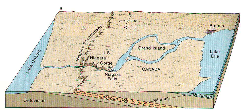
"Niagara Falls," is actually a combined term for three waterfalls stemming from the Niagara River. That trio includes Horseshoe Falls in Canada, and the American and Bridal Veil Falls in the U.S.

map_river_escarpment.gif

Through power share agreements dating back to the early 1800’s, the Niagara River annually provides 2.7 Million Kilowatts of power to the US and 2.2 million kilowatts to Canada. That’s enough to provide power to 3.8 million homes.

The Niagara Falls used to erode almost ten yards a year, but currently that number is more like an inch. That’s because 75% of the water that would flow over it is diverted to produce the electrical power generated.

Niagara Falls has stopped flowing twice. The first, in 1848, was due to ice which broke up in Lake Erie, flowed into the mouth of the river, and refroze. While it started flowing again after thirty hours, all businesses and homes dependent on it for power were shut down.

American Falls diverted during erosion control efforts in 1969

American Falls diverted during erosion control efforts in 1969

It was intentionally shut off in the late 1960’s so that rock slides, which threatened to choke the river, could be engineered to safety. When it stopped flowing, three bodies were found: a man, a woman and a deer.

A third stoppage has been scheduled for years, and will be done to replace two bridges. That stoppage could last five to nine months.

The Old Salt Ponds

by Bob Zlomke

My wife and I have rediscovered the old salt ponds, located in the Napa-Sonoma Marshes Wildlife Area. If you haven't been there in a while, you turn south on Buchli Station Road from Las Amigas Road in Carneros, and drive to the end. When you get to the parking lot, you're there.

We were there with our dog on a recent winter afternoon and decided to head west from the parking lot, instead of taking the more obvious trail southward that we usually follow. There was a concrete building in sight, which we took as our first objective. This good-sized derelict building, perhaps thirty feet by sixty in plan, was thoroughly adorned with graffiti but would have stood out anyway in that empty marsh, so we stopped to wonder what it had been built for. There wasn't much left of it but the sturdy concrete walls and floor. Volunteer artists had created a red rose on the east side, above the door, and a blue rose on the north side, each rose three or four feet wide. I had been there before but didn't remember these festive adornments. There were probably some graffiti there before, but a collective art work like that is always changing. It evokes the marsh around it, which is steadily reverting to its old ways, before salt was made here.

marsh-collage.png

To get back to the trail from the concrete building, we headed overland, and that brought our dog to life. This dog was born to pull on a leash, but now she went into high gear. She followed an irregular path over the uneven terrain, darting left and right. Whether she was following the varied scents or finding the most convenient footing, we couldn't say. We saw numerous tundra swans, a few egrets and at least one hawk, and there were smaller water birds I couldn't identify. The dog was quite interested in the birds, along with the gopher holes and traces of other wildlife. We saw the water birds all swimming away from us and imagined that we were disturbing them, which we might have been -- even as we were overwhelmed by the restful quiet of the scene. But it seems most likely that they were not interested in us, since we were neither a threat nor a food source.

There were subtle signs of human activity, both present and past. We spotted a fair-sized jet plane coming in for a landing at the nearby Napa County Airport, one so large that I had trouble believing it was coming to our small airport. There were also two smaller propeller planes that looked the right size for Napa. As we walked, we saw a few signs of old infrastructure: substantial rusty machinery that must have been a serious investment once, and a camouflaged tin shed, perhaps a hunter's blind, now converted into an information kiosk.

We eventually circled back to the parking lot in a counter-clockwise direction, having walked 3.8 miles according to Evelyn's fitbit. As we left at 4 pm, there were fifteen vehicles in the parking lot, but we had only seen two other groups the whole time and even then we weren't close enough to say hello. An unleashed dog with one group did not get close enough to rouse our normally excitable dog, who also didn't seem to mind hearing shotguns in the distance on a couple of occasions. Today she was focused on the marsh wildlife, seemingly proof against human distraction -- giving her attention to what was actually going on then and there.

When we got home I went straight to the 7.5 min USGS quad sheet (Cuttings Wharf), with what I thought was a good memory of the route we'd followed, but I couldn't find anything. Resolved: print a copy of the map and take it along next time.

2019-2020 Napa River Fish Report 

Report by Napa RCD

In 2009, Napa RCD began the Napa River Watershed Steelhead and Salmon Monitoring Program with the goal of better understanding steelhead trout and Chinook salmon populations in the Napa River watershed. Since the program was initiated, Napa RCD has conducted annual monitoring of smolt abundance, adult returns, juvenile distribution, and genetic diversity, as funding and environmental conditions allowed.

This monitoring program is intended to provide science-based information to all stakeholders involved in steelhead and salmon management and recovery. In addition to generating data on steelhead and salmon, the monitoring program also provides information about other native fishes and tracks ecological responses to ongoing habitat restoration.

A total of five Chinook salmon spawner surveys were completed between December 11, 2019 and January 9, 2020. The surveys covered approximately 40.0 kilometers (24.9 miles) of the mainstem Napa River between Calistoga and Oak Knoll Avenue. In total, 60 salmon redds, 14 live salmon, and zero salmon carcasses were observed.

2020 represented the 12th consecutive year of steelhead and salmon out-migrant monitoring using a rotary screw trap in the Napa River. Due to exceptionally low flow conditions throughout spring, the trap was only in operation for 11 days. 1,457 fish were captured, including 11 native and 3 non-native species. Native species comprised 99.5% of the total catch and non-native fishes accounted for 0.5%.

33 Chinook parr/smolts were captured; however, the trap was not operational during the peak Chinook smolt outmigration period of May and early June. The fish may have been moving, but we just weren't able to detect it this year.

The Chinook abundance in any given year appears to be primarily dependent upon (1) natural variability in the amount and timing of rainfall, and (2) inputs of stray salmon from other river systems and/or Central Valley hatcheries that opportunistically spawn in the Napa River.

44 steelhead smolts were captured,42 of which were PIT tagged. During the past eight years (2013 - 2020) 564 steelhead smolts have been tagged. Of that total, six have been re-detected in subsequent years by the Napa River PIT tag antenna. These tagging data represent the first known confirmation of steelhead returning to the Napa River.

To read the full report, please find it here on the Napa RCD website.

Image provided by Napa RCD

Image provided by Napa RCD

Visiting the Former Salt Ponds

Last Sunday my wife and I paid a visit to the old salt ponds, down in the Napa marsh.

We hadn't been there in a while, but we remembered the way: you turn south on Buchli Station Road from Las Amigas Road in Carneros, and drive to the end. When you get there, you find a small parking lot, and before you there is a broad, flat expanse of marshlands and diked ponds. There are not many people around, nor is there much indication of human activity. There are dikes, obviously not nature's work, but any further infrastructure is a bit hard to spot at first. You do see a restroom building and a collection of small signs put up by the State Department of Fish and Wildlife.

Salt.jpg

It's very quiet there, a pleasant refuge in pandemic times. The first thing we noticed was a large group of swans on Fly Bay, to the east of us as we walked south along a levee. My wife, who pays close attention to birds, was very surprised to see them. She later identified them as tundra swans. As we continued walking, we did find some more tangible infrastructure, a collection of valves and pumps designed to transfer water between ponds. There was also an interesting small building that probably contained electrical equipment. All this equipment looked rather new -- and expensive -- and we entertained ourselves with speculations on how it was used.

There have always been wetlands alongside the lower Napa River, roughly at the latitude of American Canyon but mostly across the river to the west. However, in the mid-twentieth century we found out that you could use the natural effects of sun and wind to produce industrial salt here by evaporation, and large areas of the Napa marshes were added to the list of Bay Area wetlands sacrificed to commercial use. The Cargill company operated salt ponds there until the 1980s. However, the Cargill property was bought by the State of California in 1994, and since then the State Department of Fish and Wildlife (formerly the Department of Fish and Game) has been working to restore the salt ponds to wetland habitat.

It's a big job, essentially to undo the work of several decades spent concentrating the salt. There are around a dozen separate ponds, gradually increasing in salinity as you get further from San Pablo Bay, ranging from the sodium chloride concentration in bay water up to a concentration ten times as great. The higher the salinity, the fewer plants and animals there are, and the restoration challenge is that much greater.

I found out about the restoration project when I started working as a hydrologist with Napa County Resource Conservation District (RCD) in 1995. At that time the State was just starting this impressive project.

Today the recovering salt ponds form part of the Napa-Sonoma Marshes Wildlife Area, which can be conveniently accessed from the end of Buchli Station Road in Carneros, as we did. I believe it is open for hiking and wildlife viewing all year round, but if you want to bring a dog (which should be leashed, of course) you have to avoid the spring nesting season for ground-nesting birds. Hunting is allowed during hunting season; special rules apply to hunting dogs.

Bob Zlomke